by bali volcano | Dec 22, 2017 | Uncategorized
Mount Agung or Gunung Agung is a volcano in Bali Indonesia, southeast of Mt Batur Bali volcano, also in Bali. Gunung Agung stratovolcano is the highest point on Bali. It dominates the surrounding area, influencing the climate, especially rainfall patterns. From a distance, the mountain appears to be perfectly conical. From the peak of the mountain, it is possible to see the peak of Mt Rinjani on the nearby island of Lombok to the east, although both mountains are frequently covered in clouds.
 Balinese believe that Mt Agung is a replica of Mt Meru, the central axis of the universe. The most important temple on Bali, Besakih Temple, is located high on the slopes of Mount Agung Bali.
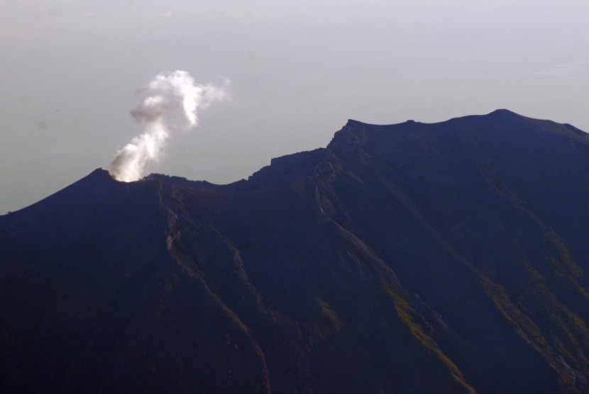
Mt Agung is an active Volcano, with a large and deep crater that occasionally emits smoke and ash. The last major eruption was in 2017, which is still active.
Mt Agung 1963–64 eruption
The eruption of 1963 was one of the largest and most devastating eruptions in Indonesia’s history.
 On February 18, 1963, local residents heard loud explosions and saw clouds rising from the crater of Mount Agung. On February 24, lava began flowing down the northern slope of the mountain, eventually traveling 7 km in the next 20 days. On March 17, the volcano erupted, sending debris 8 to 10 km into the air and generating massive pyroclastic flows. These flows devastated numerous villages, killing an estimated 1,100–1,500 people. Cold Lahars caused by heavy rainfall after the eruption killed an additional 200. A second eruption on May 16 led to pyroclastic flows that killed another 200 inhabitants. Minor eruptions and flows followed and lasted almost a year.
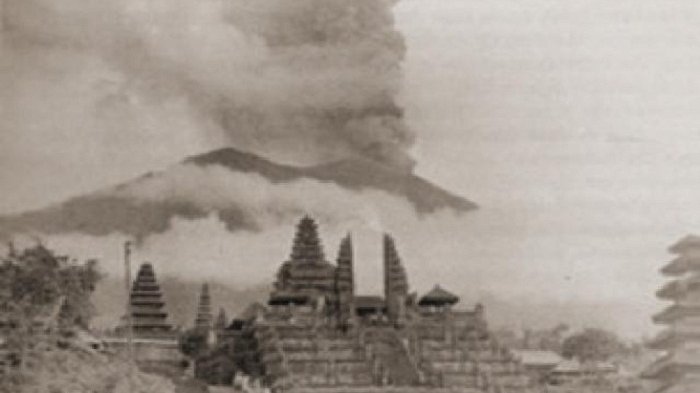
The lava flows missed, sometimes by mere yards, the Mother Temple of Besakih. The saving of the temple is regarded by Balinese as miraculous and a signal from the gods that they wished to demonstrate their power but not destroy the monument that the Balinese had erected.
Andesite was the dominant lava type with some samples mafic enough to be classified as Basaltic andesite.
Activity and eruption of Mt Agung 2017
 In September 2017, the area experienced 844 volcanic earthquakes, peaking at 300 to 400 earthquakes on 26 September. The frequency and intensity of these quakes caused much alarm among seismologists, as similar volcanoes have historically been known to erupt with even fewer warning signs.
In late September, as a result of the increased rumbling and seismic activity around the volcano, the alert level was raised to the highest level and about 122,500 people were evacuated from their houses around the volcano.The Indonesian National Disaster Management Authority Indonesian National Disaster Management Authority declared a 12-kilometer exclusion zone around the volcano on September 24. Evacuees gathered in sports halls and other community buildings around Klungkung, Karangasem, Bangli, Buleleng and other areas. The monitoring station is located in Tembuku, Rendang, Karangasem Regency, from which the intensity and frequency of tremors were closely monitored for signs of imminent eruption
By late October 2017, the activity of the volcano decreased significantly, leading to lowering of the highest status of emergency on October 29.
On 21 November, activity increased once again. A phreatic eruption took place, with the ash cloud top reaching 3,842 metres (12,605 ft) above sea level. Thousands of people immediately fled the area, and over 29,000 temporary refugees were reported to be housed in over 270 locations nearby.
Early on Saturday 25 November a magmatic eruption began. The resulting eruption plume was reported to rise about 1.5-4 km above the summit crater, drifting towards the south and dusting the surroundings with thin layer of dark ash, leading some airlines to cancel flights bound for Australia and New Zealand. An orange glow was later observed around the crater at night, suggesting that fresh magma had indeed reached the surface. On 23:37, 26 November 2017 (GMT), another eruption occurred, the second in less than a week. Ngurah Rai International Airport was closed 26 November, 2017, leaving many tourists stranded. Lahars were reported in the Selat district south of the volcano. More than 100,000 people in a 10 km (6 mi) radius of the volcano were ordered to evacuate. Australia’s Bureau of Meteorology reported on 27 November that ash from the eruption had been observed at an altitude of 9,144 m.
So far, the eruption seems to be VEI 2 on Volcanic Explosivity Index. Type of the eruption is Vulcanian or Sub-plinian.
On 27 November the Indonesian National Disaster Management Authority announced that the level of alert had been raised from Level 3 (Siaga, or Alert) to Level 4 (Awas, or Warning), the highest official warning level, as from 6.00 am on 27 November. At the same time, a general warning was issued for all persons to refrain from any activity of any kind in the Estimated Danger Zone (Zona Perkiraan Bahaya) located within 8 km of the crater of Gunung Agung and, as well, in the wider sectoral area in the northeast region towards the sea and the south and southeastern hinterland of the mountain out to 10 km from the crater.
In the beginning of December, the eruption powered down to minor emissions of steam and smoke. There are no reports of new volcanic ash on ground Flights were suspended for about three days, and were resumed by 4 December.
An eruption causing an ash plume some 2 km high occurred on the morning of 8 December, the ash being carried westward away from main population centres on the island.
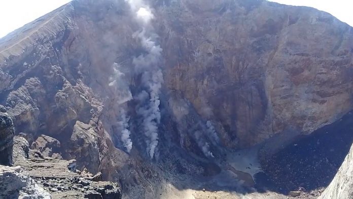
On 12th December a picture of the crater was taken showing a steadily growing lava dome occupying approximately one third of the crater. Three scenarios are possible: 1. Eruption stops as no more gas is available to bring more lava to surface. 2. Lava dome continues to grow slowly, bringing no explosive eruptions. In this scenario the main danger would be if the summit crater fills up, as the dome could collapse producing massive pyroclastic flows. 3. The lava dome forms a crust with gasses collecting underneath, until a critical pressure build-up would lead to a violent plinian eruption.
by bali volcano | Dec 22, 2017 | Uncategorized
Mount Batur Sunrise Trekking
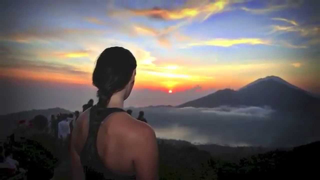
Mount Batur Trekking is one popular activities in Bali to see amazing views from the top of mount batur. Join with us to get amazing trekking adventure on the active volcano, Mount Batur trekking Starting in the dark of the early morning, we’ll ascend to the highest peak and crater for a glorious sunrise and stunning morning views. Before see the sunrise we will have breakfast with tea and eggs, bananas boiled by volcanic steam. During our descent, we will explore the three younger craters and the most recent larva flows and enjoy the amazing volcanic landscape. During on the way back to your hotel we will visit the amazing place unforgettable experience in Bali, stop on the coffee plantation called Luwak Coffee. There, you can enjoy local product is maked by their self hand (local people) there are lot of local product like, Chocolate, Luwak Coffee, Green Tea, Lemon Grace Tea, Bali Coffee, act. you can choose and taste many kind of product with free if you like it you can buy the product inside.
Mount Batur Volcano Trekking Itinerary:
01.30-02.30: Pick-up time at your hotel.
03:30: Arrive at starting point, introduction and safety procedure briefing by our English-speaking guide /Tour Guide
03.45: Begin trail trek to Mount Batur.
05:45: Arrive at the summit
06:15: Enjoy the spectacular views and sunrise. While enjoy refreshments of hot tea and eggs, bananas boiled by volcanic steam
07:00: Continue our trek around the entire crater & Explore the main crater
09:00: Arrive at finish point
09:30: Visiting coffee plantation
11:30-12.30: Arrive back to your hotel.
What Should To Bring:
• Trekking Shoes or Sport Shoes
• Warm Jacket & Backpack
• Long Pant
• Camera
Facilities Include:
• Pick Up and Drop Off By Air Conditioned Car (private tour)
• Private English Speaking Guide
• Head Torch & Trekking Pole
• Bottle Mineral Water
• Hot Tea/Coffee and Boiled Eggs, Bananas at The Summit
• Entrance fees to Kintamani Area
Pick Up Time:
Nusa Dua : 01.15-01.30 a.m
Kuta, Sanur, Seminyak, Canggu : 01.30-01.45 a.m
Ubud : 02.15-02.30 a.m
